 NI 43-101 Technical Report - Chester Project
The Chester Copper Property was formerly known as the Clearwater project and located about 15 miles to the southwest of the former Heathe Steele Mine and about 35 miles northwest of Newcastle was discovered by Kennco Exploration in 1955. The ore zones dip under the Clearwater stream, a tributary of the Sevogle River. Subsequently the claim group was acquired by the Chesterville Mines limited in the late 50’s who performed geophysical surveys and diamond drilling on the property which indicated a sizeable copper deposit. In 1966 the Sullivan Mining Group optioned the property and carried out 10,000 feet of Diamond drilling. In 1967 the Sullivan Mining Group exercised its option and formed the Chester Mines Limited. Their plan was to put the mine into production. Subsequently they completed 1700 feet of ramp and u/g development. By 1972 the price of Copper had fallen and the project was shelved
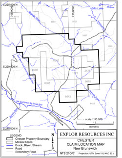
The Chester Copper Property now consists of a total of 114 contiguous mineral Claims units located in the southern edge of the Bathurst Mining Camp (BMC). It is located approximately 50 kilometres WNW of Miramichi City and approximately 70 kilometres SW of the City of Bathurst. The property is easily accessible from Bathurst via Highway 134 to Miramichi and an all-weather paved road to the property.
New Brunswick is the home to the No. 6 and the No.12 massive sulphide deposits (Brunswick Mines). The latter has been in continuous production since 1964 (to date, Feb 2013, 135,903,168 tonnes milled at 3.44 % Pb, 8.74 % Zn, 0.37 % Cu and 102 g/t Ag). The Brunswick deposits (No 6 and No 12) are situated in the Nepisiguit Falls Group of rocks in the Lower Tetagouche group of the BMC. There are 46 known VMS deposits in the BMC.
The Chester Property is known to contain both a copper deposit and a VMS deposit. There are 3 zones noted in the file to the main copper deposit, the Central Zone, the East Zone and the West or Copper Stringer Zone. Only the West Zone has been used for NI 43-101 resource calculation. The copper deposit has a Measured & Indicated resource of 712,000 tonnes grading 1.94% Cu, 0.09% Zn & 4.9 g/t Ag and an inferred resource of 920,000 tonnes grading 1.76% Cu (assayed for Cu only). Note 1
The additional claims are located on both the western and southern boundary of the Chester Property. The new claims located on the western boundary cover the western part of a detailed geological mapping, prospecting and soil sampling program that was conducted in 2011 and 2012. A copper soil geochemical anomaly was defined that covers an area approximately 800 m wide in an east-west direction by 1.2 kilometres long in a north-south direction. Additional prospecting found copper mineralization near surface in float and outcrop.
There appears to be numerous untested drill targets as shown on the soil geochemical surveys and previous geophysical survey. These were found to be within the Clearwater Stream Formation. It is anticipated that this new mineralization may be correlated down dip to the southeast and southwest of the know mineralization found in historical holes S-435 and S-436. These two historical diamond drill holes intersected very intersecting values. Hole #S-436 intersected 23.16 meters of 1.53% Cu, 1.55% Pb and 0.94% Zn, and Hole #S-435 intersected 20.85 meters of 1.43% Cu.3 The holes are approximately 140 meters apart and about 320 m in depth.
- These “historical resource estimates” are not “current resources estimate”. The “historical resources estimate” and 0.5% Cu cut-off grade is based on a NI 43-101 technical report entitled “Technical Report Chester Copper Property New Brunswick Canada” dated May 30, 2008 (effective March 20, 2008) prepared by Robert C. Sim, P. Geo., and Bruce M. Davis, FAus IMM for First Narrows Resources Corp and filed on www.sedar.com by First Narrows Resources Corp on June 3, 2008. Mr. Sim was the independent Qualified Person as defined by NI 43-101, and was responsible for the “historical resource estimate”. Explor has not taken steps to identify on what work needs to be done to upgrade or verify the “historical resource estimate” as “current mineral resources” or “mineral reserve” and a qualified person from Explor or independent third party has not done sufficient work to classify the “historical reserve estimate” as “current resources estimate” or “current mineral reserve”. Explor is not treating the “historical resource estimate” as a “current resources estimate” or “mineral reserves”. At present, to the best of Explor’s knowledge, information and belief, there is no new material scientific or technical information that would make the disclosure of the “historical resource estimate” as stated in the “historical resource estimate” contained in the 2008 NI 43-101 report as inaccurate or misleading.Estimations were made using ordinary kriging with a nominal block size of 2 meters. The resource estimate was generated from drill hole sample assay results and the interpretation of a geologic model which relates to the spatial distribution of copper and silver. Interpolation characteristics were defined based on the geology, drill hole spacing and geostatistical analysis of the data. The resources were classified by their proximity to the sample locations and are reported, as required by NI 43-101, according to the CIM standards on Mineral Resources and Reserves.The mineral resource estimate was based on a 3-D geologic and mineralization model that integrates all exploration work on the project as of March 20, 2008. A rigorous quality control and quality assurance protocol was used on the project, including blank and reference samples with each batch of assays. All drill samples were analyzed by ICP at Activation Labs in Ancaster, Ontario, Canada. The 2006 and 2007 drill program and sampling protocol was managed by Ernest Brooks, P. Geo, CIM and F.G.A.C., the Qualified Person as defined by NI 43-101 for the Chester project. Assay quality control and quality assurance standards were managed by Mr. Sim and Mr. Davis.
- Source of this information is from the New Brunswick Ministry of Energy and Mines – Mineral and Petroleum’s mineral occurrence database Reference No. 71. In 1966, Sullivan Mining Group became owner of the property under the name Chester Mines Limited. Details of Holes #S-1 to S-228 are found in Assessment Report 470750 and details of Hole #S-228 to S-438 are found in Assessment Report 470747.